As I mentioned yesterday there was some confusion about the where I was going today, my goal was Chimney Rock, which I learned about in The Ten Best of Everything National Parks book, there was also Scotts Bluff National Mounment which seemed to be a bit of a mystery. Since the monument was just a few miles from the campground I went there first thing to check it out.
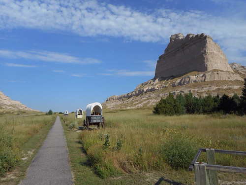
Wow! What a neat spot! Scotts Bluff is a huge collection of bluffs and badlands (like in South Dakota) that just rises up out of nowhere! It's all flat and then there's the bluff! It's long and high! And the wagon trains on the Oregon, California and Mormon Trails all went over it, as did the Pony Express. Well, at first they had to go around it until they built a passage over Mitchell Pass! This was the first scenery change the pioneers had seen in months and it signaled that their journal, from Independance, MO was 1/3 over.
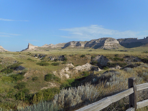
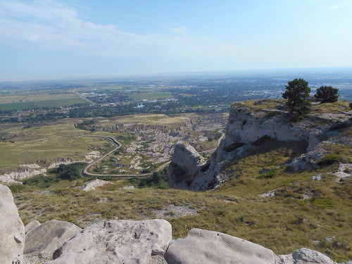
You can drive to the top of bluff and it's really neat to see all the flat that surrounds it! The road up is only a mile, but it's twisty and has 3 tunnels. Large vehicles are prohibited, but the Ranger at the entrance station said my van would be fine. They have a free shuttle that will take you up, but the Ranger seemed to be encouraging me to drive myself up, so I did.
At the top there are two short trails to take you out to viewpoints. There's a third trail that leads down to the visitor center but it's closed in the middle because of a rock slide. I was glad I was here early (they open at 8, I wasn't sure but came out early) because it was already hot, however the low angle of the sun made taking pictures to the east really hard! After I checked out all the views I headed back down to the visitor center.
Next I checked out the visitor center and got the all important passport stamp! The video and exhibits were very informative! Not only was the bluff important to the pioneers, but it has a lot of geological significance. All told I spent an hour and half here , before getting fuel and moving on down the road.
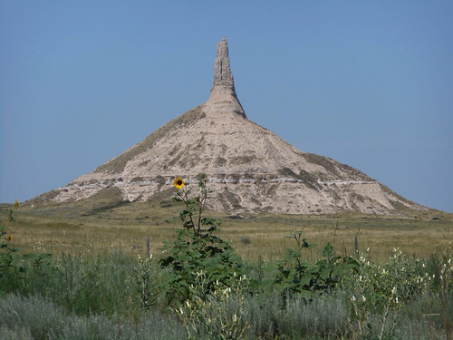
My next stop was Chimney Rock, which is about 30 miles away. You can almost see Scotts Bluff from Chimney Rock! There isn't as much to do at Chimney Rock, it's mostly just a visitor center and you can view the rock. There are numerous signs warning of rattlesnakes and cautioning everyone to stay on the sidewalk, so you just look at the rock from afar and check out the exhibits. Chimney rock also has geological significance, it was an old volcano! They had a neat map on the will of all the historic trails and it seems they just built the highway right over the old trail - I-80 and US26 were both pretty much the route of the Oregon Trail.
Chimney Rock is further east than Scotts Bluff so the pioneers saw it first and it was a signal that the prairie was just about over. This was good news and bad. The good news is that they'd made it a really long way and had a lot of celebrating to do. The bad news was that the terrian was changing and the mountains presented their own challenges. It was a moment of victory and fear of what's coming. Having driven across the county I can really relate to what the pioneers must have felt at that moment, granted I'm traveling in luxury, but even at 70 mph, the prairie is long!
After Chimney Rock it was time to get serious about driving. I wasn't sure where I was going to end up tonight, but it had to further east than where I was. I headed down 26 for almost 100 more miles of nothing. I got on I-80 at Ogallala and it was actually a relief! The US route is nice because you see more, but the interstate is easier driving. I crossed into central time and lost an hour! Ugh! Traveling east!
I decided to call it a day in Kearny, NE, which is the site of Ft. Kearny, a stop on the Oregon Trail! I didn't stop at the State Historic Park with the fort, I just continued on to the state recreation area that has a campground. The campground has 110 sites and maybe 40 are filled! It's only minutes from I-80, has electric hook ups, is only $20 a night and it's very nice! The sites are spaced out, almost all on small lakes (although the lakes do have an "aroma") that are part of the North Platte River's marshy area. There are also huge trees providing lots of shade! It's a big park so after dinner I got my bike to explore. I have a cell signal so I was able to update my blog! It was actually rather nice to sit outside! There was a breeze and some clouds that cooled things off!
Around 7:45 the gal from the pay kiosk came around to tell everyone there was severe weather to our west and it was expected here in about an hour. She said it was high winds and rain but no tornadoes. I've been keeping an eye out but so far nothing is coming (it's now 9pm). There are clouds off to the southwest but the sun just went down in a blaze of glory and now the crickets and frogs are getting going! The breeze that was so nice has even died down. Some rain would be nice, I haven't had a rainy day since July 2 in Salina, KS!
No comments:
Post a Comment