Sleeping in the Ranger Station Parking Lot makes it a lot easier to get answers to the the fire questions this morning! We went into the ranger station around 8:30 and it was already packed with people asking questions about how to get around the road closure. We didn't get much new information, we'd been able to get the most up to date information about the fire from Facebook! We did learn that WYDOT was wrong about a closure they had listed, which meant we could choose a northeastern detour or southwestern route. Both were about 300 miles. I voted for the southwestern route because I was planning to use the northeastern route when I go home. The southwestern route would allow me to see some parts of Wyoming and even a teeny bit of Idaho that I wouldn't have seen otherwise.
We called and reserved overflow camping spots at Wolf Den RV Park in Thayne, WY, then went and got a few things at the grocery store/hardware store that was in the parking lots next to the Ranger Station. Then we were off, heading on the scenic route to Jackson.
The first 150 miles were exactly like the 150 miles we drove yesterday. Flat sagebrush as far as you can see. And, there were even fewer towns! It was really very remote and very barren! So much wide open space!
About 15 miles outside of Kemmerer was Fossil Butte National Monument. I'd never heard of this one before I'd seen it on the map, but it was a passport stamp and I had to stop! It made for a good lunch and stretch your legs stop! There wasn't much to see, it was even more about the prehistoric times and the wealth of evidence found in this area about life in prehistoric times. We did meet a neat young lady in an RV who is traveling to all the National Parks in one year. It was fun to talk to her! You can find her on Facebook at 48in366.
After Fossil Butte we continued around and started heading north rather than west and the scenery began to improve! Slowly there were more hills, more plants, and slowly we began to climb! It wasn't long before I reached the top of Salt RiverPass (7,630)! There was a pullout at he top with great views!
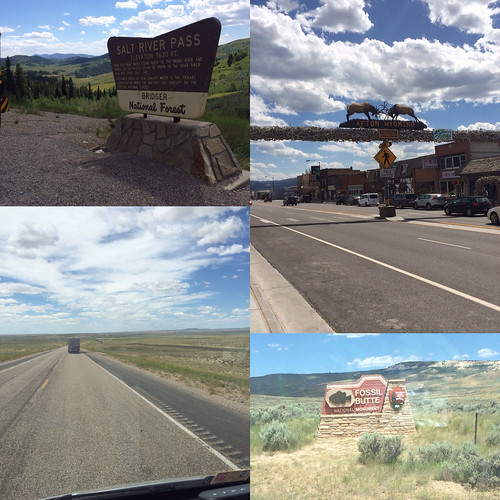
After I came down from the pass I was in the Star Valley. I'd met a lady while I was getting fuel this morning who said the Star Valley was really nice! She was right! There are mountains on all sides and a big flat valley filled with farms! Soon I came to the town of Afton which featured the largest elk antler arch in the world!
It was only about 20 miles later that I reached the campground. Carla, who needed to check us in, had run to the bank, I talked to her when I arrived. So while I was waiting I went to check out the resteraunt that was right on site. They had blackberry milkshakes so I had to sample one. It wasn't quite as good as the place in Sisters, OR, but it was tasty. Mom and Dad pulled in just then so they got ice cream too, then we got checked in to our makeshift sites. 2nd time this trip I've gotten into a campground only because I was willing to be tucked away in sub standard site! This one has water & sewer, but no electric! It works because I need to dump and put on water!
We spent the evening doing laundry, returning to the resteraunt for dinner, doing some cooking, washing to bugs off the windshield andwalking around, and around the campground to get my steps.
No comments:
Post a Comment